Townsville SOE home page

Funded by: Urban Stormwater Initiative

CBD Urban Waterway Project

Environmental Monitoring of the CBD Urban Waterway Project;

Read about the project on the USI website: CBD Urban Water Project.


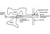
Lakes 1 & 2

Indicators: biodiversity - species richness; Aquatic Habitat Quality: water quality (physico-chemical), sediment quality, algal blooms, litter accumulation.
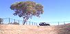
Monitoring Measures: Ongoing biodiversity monitoring/assessment; water monitoring/analysis for parameters: pH, conductivity, temperature, DO, turbidity, TSS, TOC, Alk, NH3, NOx, PO4, E. Coli, faecal coliforms, dissolved metals. Assessment of particle size distribution and metal concentrations in sediments. Identification of algal species and monitoring of algae bloom frequencies. Surveying and clean up of litter.

Townsville Lakes. Townsville Lakes Stormwater Management #1. Townsville Lakes Stormwater Management #2. Townsville Lakes Stormwater Management #3.

Townsville Lakes 1 & 2 Stormwater Management Map.There are two artificially-created lakes in Townsville designed as detention basins for flood management and also as recreational facilities. The Lakes 2 USI project is a linear stormwater treatment system incorporating a litter trap, rock-lined channel, gross pollutant trap with tri-lock and a freshwater wetland and another rocklined channel. The system cleans stormwater from a light industrial area that feeds into the Lakes. Sunfish, Townsville Port Authority and Conservation Volunteers Australia are involved in the environmental monitoring of the site.

Townsville Lakes Stormwater Management #4. Townsville Lakes Stormwater Management #5. Townsville Lakes Stormwater Management #6. Townsville Lakes Stormwater Management #7.


Curralia (Lakes 1). Curralia (Lakes 1) viewed from the west with Castle Hill in background. This artificial lake was constructed for stormwater flood management purposes and has become the gross pollutant trap for the catchment. However, it also has significant fish habitat values which are inconsistent with its GPT characteristics.

 Baseflow Channel. Rock-lined baseflow channel looking upstream to the artificial wetland.

Sediment Basin. Sediment basin downstream of the multiple-barrel stormwater outlet. Rock-lined entry point provides secondary treatment of drain seepage flows.

Artificial Wetland 2. Artificial Wetland 1.Artificial wetland for low-flow treatment and lakes water circulation and treatment.

Rock-lined water treatment system. Rock-lined water treatment system from artificial wetland to Lakes 1. This baseflow rock treatment system provides both low-flow continuous water treatment and recirculation
tertiary treatment (ie. from lake via filters to artificial wetland and back to lake).

Lakes Schematic
Lakes 1 & 2 Schematic


Railway Yards

Indicators: Aquatic Habitat Quality - water quality (physico-chemical).
Monitoring Measures: Water monitoring/analysis for parameters: pH, conductivity, temperature, DO,TSS, dissolved metals, SO4, Cl.

Due to Townsville's industrial base, many sites have potential contamination issues that could cause downstream water quality problems. One such site is the Townsville railway yards on the north side of Ross Creek. Running beneath the railway yards site is a concrete stormwater drain between Flinders Street West and Ross Creek. It was believed that the pipe had become fatigued with age and was allowing contaminants from the soil to enter the Creek. Using funding provided by the Urban Storm Water Initiative, the 100m long stormwater pipe has been lined with plastic. Using riblock lining technology, this project has extended the longevity of the concrete pipe and has prevented the intrusion of contaminated water from the railway yards into the pipe.

Stormwater inlet on Flinders Street West.Railway site stormwater inlet on Flinders Street West. The stormwater drain which flows through contaminated land to Ross Creek has been upgraded with riblock lining to trial
separating stormwater from otherwise contaminated groundwater.

Riblock-lined drain to Ross Creek. The Ross Creek end of the riblock-lined underground stormwater drain which crosses contaminated land.

Ross Creek outlet.Ross Creek outlet to riblock-lined drain showing the tidal non-return flap.


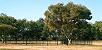
Reid Park

Indicators: Aquatic Habitat Quality - litter accumulation, water quality (physico-chemical), sediment quality.
Monitoring Measures: Timetabled surveying and clean up of litter; water monitoring/analysis for parameters: pH, conductivity, temperature, DO, turbidity, TSS, TOC, Alk, NH3, NOx, PO4, E. Coli, faecal coliforms, dissolved metals; Assessment of partical size distribution and metal consentrations in sediments.

Artificial Wetland Artificial Wetland Sediment Trap Artificial Wetland

Townsville has grown in area a great deal since its inception. Consequently, what used to be the outskirts of town has become more and more part of the inner city. Landuses of the past, such as landfills, can therefore be found in the middle of built up areas. Once such landfill site lies under Reid Park.

Gross Pollutant Trap Gross Pollutant Trap Gross Pollutant Trap Gross Pollutant Trap

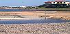
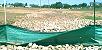
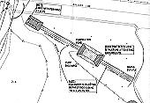
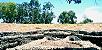
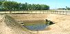
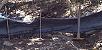
Built into an innercity former landfill site, this trilock lined gross pollutant trap feeds water into a constructed tidal saltwater wetland for nutrient scrubbing and sediment removal. Both the GPT and the wetland are tidally flushed.


Gross Pollutant Trap Gross Pollutant Trap
The gross pollutant trap was dug out of an old land fill site and provides both gross pollutant and primary sedimentation. The GPT is very low in the landscape and is tidally flushed.

Joining Pipes Joining Pipe

Stormwater moves from the GPT to the artificial wetland through these pipes. Similarly, during high tide, these pipes conduct water to tidally flush the GPT.

Sediment Trap View of the rock constructed (gabion baskets) tidally flsuhed artificial wetland. This system was excavated back into landfill which, although expensive, is the only practical way of improving options for recreating water treatment complexity prior to drainage discharge to Ross Creek.

Artificial Wetland Artificial Wetland Artificial Wetland
In time, this area will fill with sediment and will be colonised by mangroves. It is envisaged that this wetland would be maintained (sediment and wetland plant removal) once every 5-10 years.

Sediment Trap This trial artificial wetland abuts the mangroves on Ross Creek immediately downstream of the GPT and sediment basin. Due to site constraints (landfill, tidal flooding and lack of space) this wetland compresses treatment functions and incorporates combined rock filtering and saline wetland characteristics (note: mangrove plants and grasses have since been planted and this will be supplemented by natural mangrove colonisation. In the future, these mangroves are expected to be extracted under permit thereby removing pollutants.

TrilockTrilock makes a tough surface on the batter of the GPT. Below the trilock is sealed to prevent groundwater intrusion from landfill and saltwater intrusion into the landfil.


Townsville City Council Home PageCouncil's Environment Management Services