 |
| Environmental
Action Through Community Monitoring
|
Waterwatch is a national community water monitoring program funded by the Commonwealth Government’s Natural Heritage Trust. Waterwatch enables communities to become involved in the monitoring and management of waterways in their catchment. The program aims to build community understanding of water quality issues, and to encourage monitoring groups to undertake actions to rectify water quality problems.
The Waterwatch network is made up of individuals, community groups and school groups who undertake a variety of biological and habitat assessments as well as physical and chemical tests to build up a picture of the health of their waterways.
Waterwatch groups across Australia have initiated many positive, community based conservation activities such as fencing areas of riverbanks, removing litter from waterways, eradicating weeds, and reducing the use of pesticides and other pollutants.
Background
 Waterwatch
Australia was established in 1993 by the Commonwealth Government.
Waterwatch
Australia was established in 1993 by the Commonwealth Government.
Waterwatch began in response to growing concerns over declining water quality, and as a means for the Commonwealth Government to work with State and Territory governments to encourage community based solutions to environmental problems. Waterwatch contributes significantly to meeting the community involvement aspects of the National Action Plan (NAP) for Salinity and Water Quality.
Objectives of Waterwatch
< >Waterwatch is an important element in the conservation of waterways. These vital systems are threatened by unsustainable levels of water extraction, the destruction of aquatic and riverbank habitat, weed growth, algal blooms and rising levels of salinity, silt and pollutants.
Waterwatch is successfully addressing these issues by efficiently pursuing its objectives and expanding the network. The vision for Waterwatch Australia is healthy waterways. The goal for Waterwatch Australia is to have community groups and individuals active in the protection and management of waterways.
The objectives of Waterwatch are:
- An increased awareness and understanding of the importance of healthy waterways and the relationship to land uses within the catchment.
- Communities monitoring their local waterways
- Community involvement in planning and action to address waterway and catchment issues
- Effective partnerships between all sectors of the community working towards healthy waterways.
- Financial and institutional support for the Waterwatch Australia network
Major National Achievements
- Since Waterwatch began in 1993, the number of monitoring groups
has grown from 200 operating in 16 catchments, to over 3000 groups
in 200 catchments. Estimates indicate that over 50,000 Australians
are participating in the program and regular monitoring occurs at
over 5,000 sites nationally.
- Across Australia data is collected by monitoring groups using nationally
adopted protocols for nine parameters (macroinvertebrates, dissolved
oxygen, temperature, pH, conductivity, turbidity, reactive phosphorus,
nitrogen and riparian habitat assessment) and recorded using nationally
agreed units and national site code systems.
- Over 130 regional coordinators are supported to varying degrees
by Waterwatch Australia. These employees train others to get involved
in water quality monitoring.
- Waterwatch Australia has developed a National Database Program that
allows community data to be pooled, analysed and interpreted at the
catchment level and beyond. The system can also produce reports for
use by water management authorities. All Waterwatch groups use a standard
database so results can be easily exchanged, and merged at either
State or National levels.
- Waterwatch Australia has developed national community monitoring
procedures and data confidence guidelines to ensure that community
data is being collected in a consistent and credible way.
Waterwatch in the Burdekin Dry Tropics
 The
“Addressing Waterway Health” Waterwatch Project, funded
by the Natural Heritage Trust started in the Burdekin Dry Tropics region
in July 2001.
The
“Addressing Waterway Health” Waterwatch Project, funded
by the Natural Heritage Trust started in the Burdekin Dry Tropics region
in July 2001.
Conservation Volunteers Australia (Townsville) is the manager of the project. Enthusiastic members of their Green Corps and Green Reserve programs have been trained to monitor the health of local waterways.
These teams of water quality and habitat monitors are available to help school and community groups start their Waterwatching activities.
Another important part of the project involves training individuals who will work in partnership with the Australian Centre for Tropical Freshwater Research (ACTFR) to monitor water quality at reference sites.
Reference sites are water bodies that have had minimum human impact. Water quality testing at these sites provides base-line information enabling comparison with the data from the community sites.
In the Dry Tropics, Water Quality Testing monitors Temperature, Dissolved Oxygen, Electrical Conductivity or Salinity, pH, and Turbidity (or clarity). Chemical kits to measure nitrates and phosphates are used to a lesser extent.
In fresh water, Waterbugs or macroinvertebrates are also used as indicators of Water Quality.
Waterways that are highly polluted or degraded support very little life, so the greater the diversity and abundance of small insects, crustaceans and molluscs surveyed in a waterbody, the healthier it is.
A survey of bugs is a simple but effective exercise for groups to determine the health of their local waterway. Waterbugs are always a popular and intriguing study for people of all ages.
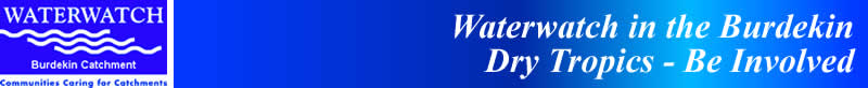
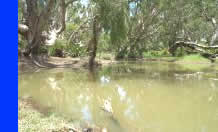
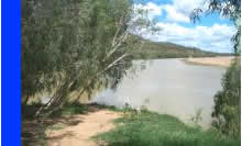
Waterwatching can take place in fresh or salty water, surface or groundwater, and still or flowing lagoons or streams.
Waterwatch, using a conceptual model of Catchment-Corridor-Coast, can play a significant role in improving the health and the biodiversity of a catchment and the Great Barrier Reef Lagoon.
Major Local Catchment Issues
Burdekin and Haughton Catchments
 These
two rivers can each be divided into 3 sections:
These
two rivers can each be divided into 3 sections:
- Grazing predominates in the upper catchment and this activity is carried out for 2/3 of the length
- Cane is the main industry in the floodplain
- The relatively narrow coastal strip has some grazing and cane, but large wetlands are the key for ecotourism income.
The Burdekin has many large sub-catchments. Some grazing occurs on highly dispersible soils. Sheet erosion hot spots are being addressed by maintaining pasture cover and improved infiltration. Water quality is also being improved by fencing stock from streams, but feral pigs are the new issue.
Cane has meant large loss of streamside vegetation and wetlands. Progressive landholders are rehabilitating streambanks and removing extensive and thick carpets of aquatic weeds. Their removal dramatically improves Dissolved Oxygen levels resulting in improved instream habitats and increased fish diversity.
Ross/Black Catchment
Grazing predominates in the upper catchment with small hobby farms giving way to expanding urban development in this the most populated centre in northern Australia.
Extensive areas of Melaleuca wetlands have been cleared for semi-rural development. Recently developed techniques have minimized the risk posed by Acid Sulphate Soils.
Introduced fish (Tilapia) and instream weed (Cabomba) are potentially large problems for the loss of biodiversity and water quality.
Townsville City Council is at the forefront for developing diverse techniques to improve stormwater quality before it reaches the Great Barrier Reef Lagoon.
Major Local Water Quality Issues
Burdekin and Haughton Catchments
 The
Burdekin “Built on Liquid Gold” reflects the immense value
of groundwater to the community. Main issues include continuing groundwater
replenishment for sustainable production and to keep the saltwater wedge
away from productive land. However salinity (dryland and irrigation)
is starting to impact on parts of each catchment.
The
Burdekin “Built on Liquid Gold” reflects the immense value
of groundwater to the community. Main issues include continuing groundwater
replenishment for sustainable production and to keep the saltwater wedge
away from productive land. However salinity (dryland and irrigation)
is starting to impact on parts of each catchment.
Water quality issues indicate the diverse nature of the many sub-catchments; sediments, Total Suspended Solids, turbidity, Total Dissolved Solids, nutrients, and Dissolved Oxygen.
Ross/Black Catchment
This small catchment has many diverse earth forms which contribute to many water quality and habitat/biodiversity issues. Northern streams are short and run quickly from the coastal ranges of the Wet Tropics. To the south the floodplains are broad and streams slower and with naturally higher salts. Water quality issues in the southern areas include Dissolved Oxygen and pH.
The significant issue of stormwater is being addressed by state of the art engineering and environmental practises. Thus human impacts from this major population centre on the Great Barrier Reef Lagoon, have been significantly reduced.
In both sub-regions the construction of two very large dams has dramatically altered the nature of the hydrology of the floodplain waterways. Streams that once had periods of flow and dryness now have permanent water, significantly altering water quality, instream values and biodiversity, and riparian vegetation.
Major Local Achievements
Waterwatch in the local region has many cooperative roles with a number of community groups and schools.
Waterwatch is working with Landcare and Catchment groups in the Lower Herbert, Ross and Burdekin River catchments. Members of these groups include innovative and environmentally aware canegrowers and the beef industry, who are working to reduce sediment and nutrient runoff.
A number of schools undertake regular monitoring of their local waterway using equipment loaned by Waterwatch. Their data is used for curriculum activities and also is sent to the National Data base
A few community environmental groups are associated with Waterwatch. They include Rita Island Proress Association, Mangrove and Seagrass Watch, Conservation of Sea Turtles, and Louisa Creekwatch and Mundy Creekwatch.
For more details contact:
David Reid
Coordinator Burdekin Dry Tropics Waterwatch
Hosted by Conservation Volunteers Australia
Email: dreid@conservationvolunteers.com.au
Telephone: 4721 4077
Mobile: 041 958 4439
Fax: 4772 3077
PO Box 827 TOWNSVILLE 4810